río Suárez
Country
Colombia
Region
Boyacá, Cuninamarca, Santander
Length
172 km
General direction
NE 23.99°
Headwaters
(Without claiming to be exhaustive):
(Without claiming to be exhaustive):
Tributaries
(Without claiming to be exhaustive):
(Without claiming to be exhaustive):
Sorting
up/down
up/down
Ends near
Villanueva
Flows in
Fishes of río Suárez
(Without claiming to be exhaustive)
(Without claiming to be exhaustive)
Species
Country
Origin
Country
Origin
Length
(cm)
(cm)
AQ
(cm)
(cm)
T.
(°C)
(°C)
Bree
ding
ding
Cetopsorhamdia nasus
Eigenmann & Fisher, 1916
Colombia
Río Magdalena-, río Cauca-Einzug, río Coello, río Suárez, río Ovejas, río Bugalagrande, río Chanco, río Cañaverales, río Timba
(Tolima, Boyacá, Cauca, valle de Cauca, Risaralda)

Eigenmann & Fisher, 1916
Colombia
Río Magdalena-, río Cauca-Einzug, río Coello, río Suárez, río Ovejas, río Bugalagrande, río Chanco, río Cañaverales, río Timba
(Tolima, Boyacá, Cauca, valle de Cauca, Risaralda)

13
80
unknown
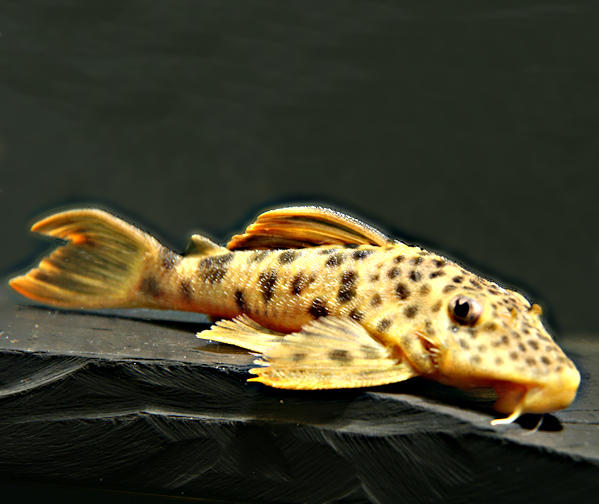
Dolichancistrus carnegiei
Eigenmann, 1916
Colombia
quebrada de Honda, río Fonce = río San Gil, quebrada Santa Rosa, río Baipé, río Magdalena-Einzug
(Santander, Boyacá)
Eigenmann, 1916
Colombia
quebrada de Honda, río Fonce = río San Gil, quebrada Santa Rosa, río Baipé, río Magdalena-Einzug
(Santander, Boyacá)

18
120
22 - 26
unknown
Eremophilus mutisii
Humboldt, 1805
Colombia
laguna de La Cocha, embalse de Tominé, río Bogota, río Suárez
(Cundinamarca, Boyacá)
Humboldt, 1805
Colombia
laguna de La Cocha, embalse de Tominé, río Bogota, río Suárez
(Cundinamarca, Boyacá)

30
180
15 - 23
unknown
Trichomycterus guacamayoensis
Ardila Rodríguez, 2018
Colombia
Cueva La Guacamaya, Quebrada La Guacamaya
(Santander)
Ardila Rodríguez, 2018
Colombia
Cueva La Guacamaya, Quebrada La Guacamaya
(Santander)
Ardila Rodríguez, C.A., 2018 "Trichomycterus guacamayoensis sp. nov. (Siluriformes: Trichomycteridae) una nueva especie de pez del Río Suárez, cuenca media del Río Magdalena Departamento de Santander"
Mesa, L.M.S.; Öassp. C.A.; Ochoa, L.E. & DoNascimiento, C., 2018 "Trichomycterus rosablanca (Siluriformes, Trichomycteridae) a new species of hipogean catfish from the Colombian Andes"
Mesa, L.M.S.; Öassp. C.A.; Ochoa, L.E. & DoNascimiento, C., 2018 "Trichomycterus rosablanca (Siluriformes, Trichomycteridae) a new species of hipogean catfish from the Colombian Andes"
13
80
unknown
4 entries found.
Many thanks to
for the pictures
Please help with your pictures and information to complete the database: database(at)welsfans.de
