río Tulumayo / río Tullunayo
río Tulumayo / río Tullunayo → río Chanchamayo (⪪) → río Perené (⪪) → río Tambo (⪪) → río Ucayali (⪪) → Amazonas (⪪) → Atlantic NE (⪪)
Country
Peru
Region
Junín
Length
105 km
General direction
NW 339.40°
Starts near
Cordillera Huaytapallana
[ -11.875,-75.063 ]
Altitude
4800 m
Tributaries
(Without claiming to be exhaustive):
(Without claiming to be exhaustive):
Ends near
San Ramón
Flows in
Altitude
800 m
Time, position
Cond.
w.temp.
pH
GH
KH
O2
10.09.96
Tingo Maria
Tingo Maria
620.00
24.00
8.50
Sep.19
340.00
20.00
6.00
Fishes of río Tulumayo / río Tullunayo
(Without claiming to be exhaustive)
(Without claiming to be exhaustive)
Species
Country
Origin
Country
Origin
Length
(cm)
(cm)
AQ
(cm)
(cm)
T.
(°C)
(°C)
Bree
ding
ding
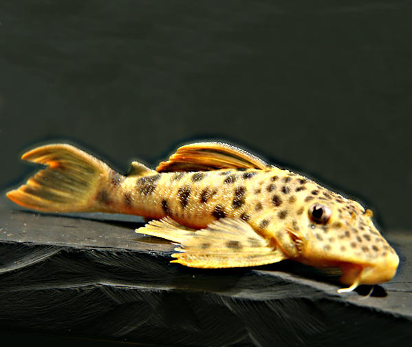
Chaetostoma changae (L 334)
Salcedo, 2006
Peru
río Tullumayo, río Monzon, río Aucayacu, río Uchiza, río Pacota, río Huainabe, río Huantanamo
(Huánuco, San Martin)

Salcedo, 2006
Peru
río Tullumayo, río Monzon, río Aucayacu, río Uchiza, río Pacota, río Huainabe, río Huantanamo
(Huánuco, San Martin)
15
100
22 - 27
unknown
Chaetostoma loborhynchos
Tschudi, 1846
Peru
río Paucartambo, río Tulumayo, río Tambo, quebrada Acomayo
(Pasco, Junín, Huánaco)
Tschudi, 1846
Peru
río Paucartambo, río Tulumayo, río Tambo, quebrada Acomayo
(Pasco, Junín, Huánaco)

>15
100
unknown
Chaetostoma sp. "L 335"
Peru
Río Yurayacu bei Shasuta = Chasuta; río Tulumayo bei Tingo Maria
(San Martín, Huánuco)
Peru
Río Yurayacu bei Shasuta = Chasuta; río Tulumayo bei Tingo Maria
(San Martín, Huánuco)
13
100
22 - 27
unknown
3 entries found.
Many thanks to
for the pictures
J. J. von Tschudi
1
Please help with your pictures and information to complete the database: database(at)welsfans.de
